
Contact

Home
Clear Mountain Yowie
Yowie / Bigfoot &/or Strange Animals
I am the Clear Mountain Yowie
by Ed Skoda ("Night Walker")
Date: June 9, 2013
While looking up information on the Mulgowie Yowie, a report from Clear Mountain, 2011, caught my eye:
Last Saturday (30 April 2011) we stayed a night at a lodge up on Clear Mountain, Queensland.
We were at the back, backing right onto dense undergrowth. We were up out on the balcony late at night for a number of hours checking out the stars and sky, and also on and off periodically throughout the night.
Each time we were out there we would hear movement in the undergrowth, nothing significant, just twigs snapping, and something that sounded like pushing through vegetation.
It would get our attention, but would stop for ages and it was too dark to see anything. Wed heard similar things when staying up at Springbrook in the past.
The next morning after breakfast we walked around the blind (eastern) side of the lodge, and noticed very large dried muddy footprints on the decked area. They came up along to where they would have come into view of the main areas, stopped, then did a u-turn and headed back.
We back traced where the prints had come from, and they had come from the undergrowth, around the side of the property and up the edge of the car park to where we saw them on the decking.
They were a good 2 inches longer than my shoe, which makes them over 13.5 inches (35cm).
They didnt seem shaped like a humans and some you could see one or two large toe marks. The mud was thick, and it was mid-morning and had dried to a light brown colour. It hadnt rained in the 20hrs we had been there, but there were garden sprinklers around. We didnt have our camera on us, so didnt get any photos.
Mark & Claire
Clear Mountain is a suburb in the Moreton Bay Region. At its highest point (238m above sea level) is Clear Mountain Lodge which provides accommodation, restaurant, conferencing, and a day spa. Encroaching upon the grounds of the lodge to the north is State Forest consisting of eucalypts and dense undergrowth intersected by numerous trails. This area is one of my favourite local haunts for hiking practice both day and night because its terrain is similar to that of the nearby mountains of the DAguilar Range but is more readily accessible.
I was the Yowie who was exploring the tracks below the lodge and pushing my way through the undergrowth off-trail that night (April 30, 2011). Having parked my car near an access gate along Clear Mountain Road down the hill about 200m from the lodge, I followed a steeply descending trail in a roughly west-northwest direction until I came upon an old wooden bench which I thought was unusual. (Maps show this area to be William Smith Park but other than the bench the area is indistinguishable from the rest of the forest.)
A lesser trail appeared to branch off to the north with the lights of Clear Mountain Lodge visible on top of the hill and through the trees. Since I was not working the next day and was eager to test out my newly purchased GPS trail-marker I thought I would explore in order to see where this trail came out.
The trail thinned out as it ascended but I came upon another old bench after which the trail became lost amongst the undergrowth. Despite the lights of lodge having receded behind the ever-steepening mount I estimated that I would be less than one hundred metres from the top so decided to keep pushing onwards and upwards in the hope of coming across a defined trail once more. No such luckthe climb was getting steeper and the undergrowth more dense. I even remember wondering if anyone could hear my progress but all seemed quite at the lodge.
I faced three options: 1) continue to work my way through the undergrowth to the lodge at the top of Clear Mountain, 2) turn around and return the way I had come, and 3) use my GPS to cut across the terrain to my original starting point. As I didnt want to go over old ground again and didnt know whether the lodge could be accessed directly from this route anyway I decided to follow the pointer on my GPS to my original starting pointthe terrain was still very steep but at least I would largely be going across rather than directly up it.
The GPS worked a treat and I eventually returned to my original starting point and even came across a disused track beside Clear Mountain Road. I followed that trail too which curved up to the back of the lodge itself. Without entering the complex I inspected its features and found a path from the car park to overgrown concrete steps leading down into the forest below before returning to my car.
I dont recall leaving behind any muddy footprints but it is conceivable that I did. The boots I was wearing at the time measure 31cm along the underside of the sole and may have smudged to extend the size of the print. The report's claim about following large muddy footprints from the the undergrowth seems contrived anywaylike something from a "Scooby-Doo" cartoonin order to add substance to the initial claim. I also returned the next afternoon and unsuccessfully attempted to find and follow the trail from the lodge to the out-of-place benches below.
There was no motion in the bush that night other than me. That makes me the Clear Mountain Yowie. Hoorah!
Postscript: I returned to Clear Mountain in the evening of June 8, 2013 in order to find the trail down from the lodge but it was even more overgrown than I remembered with several downed trees adding to the confusion. Of course I quickly lost the trail again but pressed on regardless with my new GPS watch recording my route. I wonder if there will be other Yowie reports from Clear Mountain and surrounding areas due to my night walks...
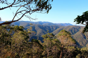
D'Aguilar Range

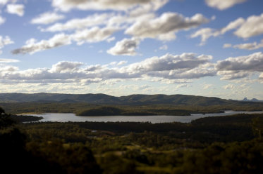
View from Clear Mountain

Rainfall during April (2011) was above the long-term average across most sites around the Brisbane area. The wettest periods were
between the 7th to the 9th and between the 18th to the 20th.